By Robin Ambrosino
In a fit of cabin fever I called my friend Thad. I’d been pressing my nose against the window for weeks, as more snow than we’d had in years created a thick inviting carpet over the landscape. But below-zero temperatures and a nasty wind chill had been keeping me from enjoying it. When the thermometer climbed to 18 degrees one January morning, I was determined to escape my house.
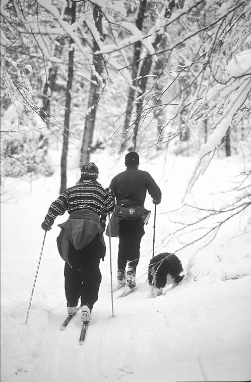
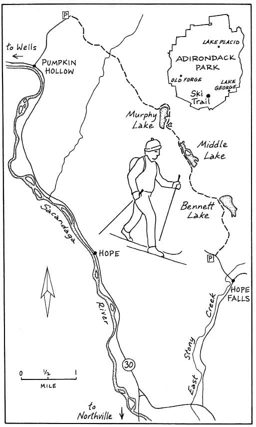
I wanted Thad to join me for a cross-country ski trip to Murphy, Middle and Bennett, just south of Wells. I had hiked to Bennett and Middle lakes before, but never reached the lean-to on Murphy Lake. I was hoping we could do a through trip by parking cars on both Pumpkin Hollow Road and Creek Road and skiing the route end to end. In my excitement, though, I forgot about Thad’s breakneck social schedule. So that day I ended up doing a solo round trip to the Murphy Lake lean-to, while Thad and I made plans to do a through trip a couple of weeks later.
The trail is a designated snowmobile route, in the Wilcox Lake Wild Forest, so it’s best to ski it on a weekday, when it sees less traffic. The forecast for my solo trip was not particularly promising: 15 mile-an-hour winds with gusts up to 25 mph. On my drive to the trailhead, the roads were covered with drifting snow. Once on the trail, however, towering pines blocked nearly all the wind.
The Adirondack Explorer thanks its advertising partners. Become one of them.
The trail from Pumpkin Hollow Road (the northern end) is fantastic. There are several fairly steep hills over the first couple of miles, but fresh snow slowed my descents to a comfortable speed, just fast enough to be fun. Guidebook author Barbara McMartin recommends that skiers begin a through trip on this end since the downhill sections make for an easier passage.
“This route has always been a favorite of mine,” McMartin said in an interview. “It’s a relatively level trip, there are several pretty lakes, and there’s some history with the paint mine. I always like a trail when it has something extra.” McMartin’s guidebook describes a former ferric oxide mine about a mile from the Creek Road trailhead. Red pigment in the soil was used to make paint at the turn of the 20th century.
About two miles in, just past Doig Creek, the trail began a series of ascents, made trickier by several wet spots where small streams crossed the path. The outlet to Murphy Lake at 3.4 miles was frozen solid, and I crossed with no problem.
When I reached the lake, the wind that had been whipping the white pines overhead hit me with a blast. I stopped to cinch my hood down over my face. I left just enough opening to watch the swirling, windswept snow form a lunar landscape of ripples that settled briefly on the surface of the lake before blowing into icy clouds around my head. Knowing the lean-to was on the east shore, but not knowing exactly where, I bent my head against the wind and hugged the shore. My skis were almost completely buried beneath the powder as I glided over the frozen lake.
The Adirondack Explorer thanks its advertising partners. Become one of them.
I must have added a half-mile to my trip by following the shore. Here’s a shortcut to the lean-to: Start at the orange “Trail” sign where the path meets the northern end of the lake. With the tall rocky ridge at 9 o’clock and a gentler ridge at 12 o’clock, head across the lake toward 11 o’clock. The lean-to shares a small knoll with some boulders and white pines. I stopped on a sunny ledge overlooking the lake to eat a sandwich and sip some hot chocolate.
The only place that gave me trouble from this direction was the ravine leading to Murphy Lake. Normally I would have sidestepped my way up. But the rut made by snowmobilers was too narrow to accommodate my skis, so I had to take them off and walk. Up until here I was glad the machines had packed the snow for me, but I wondered whether this narrow, rocky trail deep in the Forest Preserve is appropriate for snowmobiles. Later, I asked Neil Woodworth, the lawyer for the Adirondack Mountain Club, about it. “As snowmobile trails are phased out in the interior of the Forest Preserve, that’s one of the trails we’ve requested be closed,” he told me.
McMartin believes skiers need to be cautious on weekends, but she actually appreciates that snowmachines help groom the route. “I’ve never heard any talk about closing this trail, and I don’t think we should talk about it,” she said. “Wilderness Areas are closed to motors, but Wild Forest Areas can be open to designated snowmobile trails. And I can’t believe snowmobilers would give this one up.”
According to a spokesman from the state Department of Environmental Conservation, this trail gets only moderate use from snowmobiles, but no decisions have been made yet about its future.
The Adirondack Explorer thanks its advertising partners. Become one of them.
When Thad and I regrouped a couple of weeks later, we had planned for a through trip. But with another storm in the forecast, we settled on a second round-trip to the lean-to, this time from Creek Road at the southern trailhead. As we huffed our way uphill from this direction, we agreed wholeheartedly with McMartin’s suggestion to start from the Pumpkin Hollow end. We turned around before the lean-to and were a little knock-kneed during the descent back to the trailhead. The packed snow had become a lot faster since my first trip, and the route back to the car was quite steep and twisty.
Even if you consider yourself a good skier, try to pick a day after a new snowfall for this trip. The powder will make the descents easier. The through trip is 8.3 miles. If you plan to ski only as far as the Murphy Lake lean-to, the round-trip is 7.6 miles from Creek Road and 9 miles from Pumpkin Hollow Road.
DIRECTIONS
Northern trailhead: Pumpkin Hollow Road is about 4 miles south of Wells on Route 30. Go down the road 1.6 miles to a parking area on the left. The trail begins on the other side of the road.
The Adirondack Explorer thanks its advertising partners. Become one of them.
Southern trailhead: Driving north on NY 30, look on the right for Old Northville Road, which starts 4.1 miles after the bridge over the Sacandaga River. Turn and go 1.4 miles to Hope Falls Road. Turn left and go 2.8 miles to Creek Road. Turn left and go 0.6 mile to the trailhead on the right.
[mappress mapid=”55″]

Leave a Reply